Enciso Systems Validates Strategic Advantages of Colombian Equatorial Ground Station Through Advanced Orbital Simulation Platform
High-fidelity modeling demonstrates a 50% latency reduction for Sun-synchronous orbits and full coverage recovery for low-inclination satellite constellations
August 16, 2026
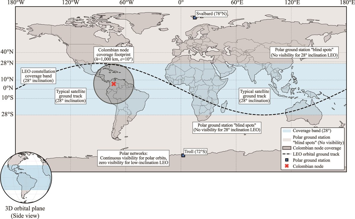
Enciso Systems announced today the publication of landmark research in the peer-reviewed journal Deep Space Exploration, utilizing its proprietary, high-fidelity orbital simulation framework to evaluate the strategic performance of a proposed equatorial ground station in Paipa, Boyacá, Colombia. By integrating complex astrodynamical propagation engines with atmospheric attenuation models, Enciso Systems proved that an Andean equatorial node eliminates historical polar coverage gaps, reduces Sun-synchronous satellite latency by 50%, and restores continuous tracking capability for low-inclination missions. The study highlights Enciso Systems' advanced capabilities in modeling space-to-ground architectures, digital signal processing dynamics, and dynamic constellation scheduling.
Traditional satellite tracking relies on a "polar-first" ground station architecture that creates severe coverage blind spots for low-inclination orbits and introduces latency bottlenecks during equatorial transits. To analyze this systemic issue, Enciso Systems built a computational simulation environment leveraging Python astrodynamics engines, SGP4 propagation algorithms, and ITU-R environmental loss models. The firm cross-validated its simulation architecture against NASA’s General Mission Analysis Tool (GMAT), achieving tight mathematical convergence with tracking discrepancies remaining below 1.97% across 30-day propagation windows [1].
The simulation results show that deploying a ground station at 0º latitude in Colombia expands daily visibility for low-inclination orbits from zero to a stochastically stable 97.5 minutes per day across ten passes. Furthermore, the station's symmetrical tracking geometry cuts peak Doppler rates by 27%, directly lowering the digital signal processing (DSP) burden on receiver loops during high-speed Ka-band downlinks [2].
"Our software simulation platform enabled us to rigorously evaluate complex orbital mechanics and atmospheric physics long before deploying physical hardware," said Javier Enciso, Principal Investigator at Enciso Systems and primary author of the study. "By proving that an Andean equatorial station achieves a reliable 50 ± 4.2 minute latency window for Earth observation platforms, we demonstrate how advanced computational modeling de-risks multi-million dollar investments in space communications infrastructure."
Addressing concerns regarding tropical rain fade in the high-frequency Ka-band (26–40 GHz), Enciso Systems parameterized atmospheric attenuation equations to Paipa's 2,600-meter altitude. The model demonstrated that high-altitude positioning bypasses the dense lower troposphere, reducing total atmospheric attenuation at 30 GHz from 35.7 dB at sea level to 19.5 dB, thereby securing a 16.9 dB link margin at 99.9% availability [3].
"The high-altitude Andean geography provides a natural engineering filter against tropical atmospheric moisture," stated Prof. Mario-Armando Higuera-Garzón, co-author and professor at the National Astronomical Observatory of Colombia. "Enciso Systems' multi-variable simulation convincingly proves that Colombia's topography mitigates tropical rain fade, validating the site as a premier egress candidate for international deep-space and multi-orbit telemetry networks."
The simulation framework also integrated automated network orchestration to resolve multi-satellite pass contentions and enforce dynamic keep-out zones around the geostationary belt, preventing radio-frequency interference (RFI). In line with Enciso Systems' commitment to open science and technological transparency, the full simulation codebase, TLE datasets, and visualization suites have been released in a public, open-access repository [4].
Notes
[1] Cross-platform verification against NASA’s General Mission Analysis Tool (GMAT R2026a) confirmed SGP4 daily contact time residuals within 1.97% for low Earth orbits and 1.21% for Sun-synchronous orbits.
[2] The direct velocity alignment between the Earth's equatorial rotation (460 m/s) and prograde equatorial satellite tracks smooths the Doppler S-curve, narrowing required phase-locked loop (PLL) tracking bandwidths.
[3] Link budgets calculated at 99.9% availability maintain a positive safety margin of +7.3 dB even under severe 3σ worst-case atmospheric distortion events.
[4] The open-access simulation codebase and dataset repository are available.
Links
- Geographic and tracking advantages of an equatorial ground station in Colombia
- Deep Space Exploration Journal
- Codebase and Dataset Repository
More Information
Enciso Systems is a technology consulting and software development company delivering reliable digital solutions for organizations operating in complex and data-intensive environments. With a strong focus on quality, security, and long-term sustainability, the company supports clients across the aerospace, scientific, industrial, and public sectors. Enciso Systems combines international experience with agile execution to help organizations modernize their operations, manage critical information, and scale with confidence.
Contacts
Press Information Office
Enciso Systems
Email: info@encisosystems.com
National Astronomical Observatory of Colombia
National University of Colombia
Email: obsan_fcbog@unal.edu.co
See These Principles in Action
Discover how we apply engineering excellence and mission-critical reliability to real-world projects for scientific and aerospace organizations.
